Lake Levels
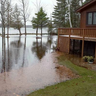
The Little Traverse Lake Association has taken a very active role in researching and seeking solutions to fluctuating water levels on Little Traverse Lake including high water levels that have damaged property and negatively impact water quality. Efforts continue in collaboration with Cleveland Township, National Park System and private engineering partners. Your donations and membership dues help support this ongoing project.
Observed and expected changes in Northern Michigan’s climate:
Storms are expected to become more frequent and more severe. Already, the amount of precipitation falling in the heaviest 1% of storms increased by 37% in the Midwest between 1958 and 2012. Due to changes in temperature and the seasonality of storm patterns, it is anticipated that increased precipitation will fall as rain instead of snow, and be concentrated in the spring and fall months. Wetter weather can strain infrastructure, cause flooding around lakes, streams and coastlines, and flush toxins into water bodies. -Cleveland Township Master plan 2017
Understanding Watershed Characteristics

LTLA monitors automated water-level sensors installed at four key locations:
- Lime Lake outlet (start of Shetland Creek)
- Little Traverse Lake at east side of Traverse Lake Road culvert (TLR Lake Inlet)
- Shalda Creek at the west side of TLR culvert (TLR Stream Outlet - start of Shalda Creek)
- Shalda Creek at the east side of CR 669 bridge.
The graphs below represent real time measurements at those sensor locations.
Additionally, its important to understand that Lime Lake drains into Shetland Creek through an open stream outlet with a minimal rock dam at the bottom and Shetland Creek empties into Little Traverse Lake on the southeastern side. Little Traverse Lake drains into Shalda Creek through a 64x43” culvert under Traverse Lake Road on the west side. Shalda Creek is an open stream channel west of TLR and passes under a 30’ span bridge at CR 669 / Bohemian Road. From there, Shalda Creek continues downstream until it crosses under Lake Michigan Drive and empties into Good Harbor Bay of Lake Michigan.
